
Listening to the rhythm of nature
When the day seems dark, gray and gloomy, there are reflections all around us of nature holding guard and setting the tone. We’re all included in that harmony, and each of us has the opportunity to reflect it a little more, moment by moment.

Fog settles on the hills by Lake Pinneo in Quechee, Vermont. (Gareth Henderson Photo)
At my desk this afternoon, I had a constant companion: the raindrops, and the art they made. Their steady tapping on the skylight created the most gentle rhythm, leaving little circles of water on the window for a half-second. They landed, and down they went — the effect of perfect music.
Naturally, they inspired me to play a few songs on my guitar, including a favorite of mine from Jakob Dylan, “Something Good This Way Comes”. As I played along, nature provided its calm, steady percussion. I added my sound to its sound, and on a rainy afternoon, the day got a little brighter. Like Dylan says, “This kind of day has no night.”
The best part is, this inspiration doesn’t need long to settle in — it only needs us to have an open mind, and pay attention. When the day seems dark, gray and gloomy, there are reflections all around us of nature holding guard and setting the tone. We’re all included in that harmony, and each of us has the opportunity to reflect it a little more, moment by moment. Ever-present good is there to guide us, and we decide how much night enters into our day. Every honest step in a positive direction welcomes more light into our experience — it helps us see that goodness in the world. That’s true progress, and our constant opportunity to thrive.
— Gareth Henderson

Hurricane Henri closes in on New England
Now a category-1 storm, Hurricane Henri is on track to make landfall in the Northeast late Sunday, though storm surge is likely to arrive in coastal areas much earlier. Some inland flooding is expected, and officials are asking citizens to prepare for the storm’s arrival.

Rainfall in the summer of 2020 in Woodstock, Vt. (Gareth Henderson File Photo)
Now a category-1 storm, Hurricane Henri is on track to make landfall in Long Island or southern New England late Sunday.
However, coastal flooding from storm surge may begin as early as tonight and intensify throughout Sunday. The storm surge along the coast is forecasted at three to five feet from Long Island to Cape Cod, leading to multiple storm surge watches and warnings along the northeastern coast, The Weather Channel reported. Officials also warn of inland flooding in the Northeast, due to forecasted rain of 3-6 inches from Sunday into Monday.
In Massachusetts, flood barriers have been put up in Boston, and the National Guard has been activated. Parts of New York are under a state of emergency. Throughout the coastal regions, people have been urged to delay all non-essential travel, especially Sunday.
This news comes after the Northeast has experienced significant rain in recent weeks, including some stray showers and thunderstorms in parts of northern New England on Saturday.
In Vermont, emergency management officials are zeroing in on southern Vermont, where Henri could have the most impact for the state, including up to six inches of rain. In Bennington and Windham counties, flooding just a few weeks ago damaged roads, bridges and culverts.
“We hope for the best but we have to prepare for the worst-case scenarios,” Chip Deasy of Vermont Emergency Management told NBC5. The storm system could also bring wind gusts of up to 50 mph.
Officials whose areas are in the storm’s path have urged people to be prepared, including making sure they have flashlights, batteries, canned food, water, and other essentials in case they lose electric service or are stranded at home for an extended period. The greatest impact in Vermont is likely to be “heavy rain Sunday into Monday in central to southern areas of the state,” according to a statement by emergency management officials on Saturday.
Check out hurricanes.gov for the latest updates.
— Gareth Henderson

Surprises from the sky
This week, Mother Nature turned it up a notch or two. I’m not talking about the temperatures, or the humidity, but the brilliant sunsets these humid days occasionally brought our way.

A view of the Monday sunset from Prosper Road in Woodstock, Vt. (Gareth Henderson Photo)
This week, Mother Nature turned it up a notch or two. I’m not talking about the temperatures, or the humidity, but the brilliant sunsets these humid days occasionally brought our way. The epic sweep of colors across the sky, illuminating clouds of all sizes, provided peaceful moments of awe and wonder as the sun gradually rolled back over the mountains and heralded the coming night.
Such an inspiring spectacle brought light to the end of a long day on Monday. Quite literally, the sun, filtered through hazy clouds, basked all our surroundings in an unforgettable pink glow. Nothing was untouched. The siding of our home, the trees, and seemingly the very air itself, carried the same pink-gold that danced on the edges of the clouds above.

A cloud glows pink and gold at Monday’s sunset in Woodstock. (Gareth Henderson Photo)
There were more colors painting the sky, but my wife and I had to drive to capture those. We went to King Farm in Woodstock to photograph the yellow-orange display that was quickly receding every minute, as it illuminated the grass in the fields. A quick drive up Prosper Road revealed one more view of the brilliant but dimming colors, before darkness started to take over.

King Farm at sunset on Monday night in Woodstock. (Gareth Henderson Photo)
At that point, it might have felt like our photo adventure was done. But it wasn’t. I wondered if the haziness had created some more visual magic down in the valley near the Pomfret-Woodstock line. We weren’t disappointed: From where Route 12 meets Pomfret Road, enough light remained in the sky to highlight blue-gray clouds in the distance, making the lower part of the sky look like one, giant rolling cloud that was moving toward us. Dusk, a time of day not famous for great outdoor photos, had created a tapestry of color and effect that would be hard to match.

Rolling, hazy clouds at dusk on Monday along Route 12 in Woodstock. (Gareth Henderson Photo)
The unexpected is what makes nature special; unpredictability is its greatest gift to the artist. On a week when the weather perhaps wasn’t our favorite thing, nature nonetheless has provided visual majesty that appealed to our sense of wonder, and perhaps, made us momentarily forget our cares. As the sun shines through, our thoughts are uplifted and we take that light with us. Indeed, there is light even in the darkest of days. Though we’ve got some rain in the Vermont forecast for the upcoming holiday weekend, maybe nature will surprise us again with a few more treasures for the camera lens. It’s not impossible. Inspiration is always evolving, and more is waiting on the road ahead.
— Gareth Henderson

Mud season — with a touch of snow
Any snow is expected to taper off by Friday evening, followed by a quick jump back to 50-degree weather on Saturday and some 60s next week. True, vestiges of winter may try to creep in, but spring wastes no time in getting back to business.

River Road in Woodstock, Vermont. (Gareth Henderson Photo)
It's one of the ironies of living in New England: With spring barely a month old, there's still a chance winter may come back, just a little. And it looks like Friday may be that kind of day in Vermont.
Nature's latest weather show opened with rain on Thursday evening. But parts of southern Vermont, including the Woodstock area, are expected to see 6 to 12 inches of snow over the course of the day Friday. A winter storm warning is in effect until 8 p.m. Friday evening for Windsor County, and the eastern portions of Rutland and Addison Counties.
During any storm warning, caution is always best. The National Weather Service is warning about hazardous travel conditions on Friday, especially on roads in higher elevations — which would include that Killington overpass along Route 4. Even if weather in the lower valleys is minimal, it can be a very different scene in areas like Killington.
Speaking of changing conditions, it's always a slight risk to write about specific weather events — because they can disappear from the forecast in the blink of an eye. With temps above freezing, Friday's weather could result in little more than slush. But however it pans out, the warm season will march confidently onward, with this storm being a blip on the radar in the grand scheme of spring.
To that end: Any snow is expected to taper off by Friday evening, followed by a quick jump back to 50-degree weather on Saturday and some 60s next week. True, vestiges of winter may try to creep in, but spring wastes no time in getting back to business. And all who've been enjoying the warmer weather are glad to know it.
— Gareth Henderson

Wintry blast continues its widespread impact
The winter storm that pummeled the country this week may have left New England, but its impact persists elsewhere with severe power outages and major delays in vaccine distribution.

The view behind the Woodstock History Center earlier this month. (Gareth Henderson Photo)
The winter storm that pummeled the country this week may have left New England, but its impact persists elsewhere with severe power outages and major delays in vaccine distribution. At least two dozen people have died this week from weather-related incidents in the U.S., according to The Associated Press.
In Texas, power had been restored to over 600,000 people by Wednesday morning, but 2.7 million homes in the Lone Star State were still in the dark shortly before 2 p.m., NPR reported. The Electric Reliability Council of Texas (ERCOT), which runs about 75% of the state's power grid, acknowledged the hardship people are enduring in the extreme cold.
"We know millions of people are suffering," ERCOT's president and CEO, Bill Magness, said in a statement Wednesday. "We have no other priority than getting them electricity. No other priority."
ERCOT asked local utilities to shed 14,000 megawatts of load, which equates to around 2.8 million households. Some municipalities urged residents to reduce their electricity usage, and many had to issue boil-water notices.
The weather's impact also hampered the Biden administration's COVID-19 vaccine distribution efforts in Texas and elsewhere. In Vermont on Tuesday, Gov. Phil Scott said White House officials warned governors that day about postponements in vaccine deliveries to different states due to the storm.
"I'm not sure how that will affect us, but stay tuned," Scott said.
On Wednesday, the delays hit some parts of the Northeast. In New York, Mayor Bill de Blasio said the city had to hold off making 30,000 to 35,000 vaccination appointments due to delayed distribution from elsewhere in the country due to weather, The Associated Press reported.
The heavy Arctic blast continued to impact Americans from the south-central U.S. to the mid-East Coast throughout Wednesday. Though some areas will see more moderate temperatures in the coming days, many will experience temps 20 to 35 degrees below normal such as the Great Plains, Mississippi Valley and the lower Great Lakes region, according to the National Weather Service.
— Gareth Henderson

Winter Storm Uri closing in on New England
Widespread winter weather has broken snowfall records across the country, and Winter Storm Uri is now heading to New England, where snow and ice is expected to begin early Tuesday.

Woodstock Village after a storm earlier this month. (Gareth Henderson Photo)
Widespread winter weather has broken snowfall records across the country, and Winter Storm Uri is now heading to New England, where snow and ice is expected to begin early Tuesday.
Not all areas are due for tons of snow on Tuesday, but forecasters are warning about snow and ice mixing on the roads in many parts of the Northeast region. In Vermont, the higher snowfall is expected to be in the north, with much of the state, including the Woodstock area, getting 6 to 12 inches. Some southern areas may see less than 6. The farther south you go, the more ice on the roads will be the main issue, said Tyler Jankoski of MyNBC5.
“The heavy snow and sleet is for all of us in the northern half of the region, with that icing south,” Jankoski said.
A winter storm warning was in effect from 7 p.m. Monday through 7 p.m. for most of Vermont, with 1 to 2 inches of snow falling per hour between midnight and 7 a.m.
What’s coming is the culmination of what’s been an epic weather event elsewhere in the U.S. On Monday afternoon, communities from the Rio Grande to the Saint Lawrence River were under winter weather advisories, and about 3 million people were without power. Most of those were in Texas, where traffic in every major city ground to a halt because of snow.
“I want to encourage people to stay home, to stay off the roads,” said Houston Mayor Sylvester Turner at a press briefing.
Oklahoma City, which also had record snowfall, had endured five-straight days of 25-degree temperatures, and states across the Plains have recorded record-low temperatures as well. The weekend brought 11 inches of snow to Seattle, breaking that city’s snowfall record for February.
As of 4 p.m. Monday, over half of the U.S. population remained under winter weather advisories.
Vermont’s COVID-19 vaccination clinics will remain open on Tuesday, but people wishing to reschedule their appointment due to the weather are asked to call 855-722-7878.
In the Green Mountains, the storm is expected to largely subside by noon on Tuesday, and sunshine and 25 degrees is in the forecast for Wednesday.
— Gareth Henderson

A state of nourishment
In a way, the rain is perfect for this holiday and its celebration of birth and renewal for the world.

A gray day along River Road in Woodstock, Vermont. (Gareth Henderson Photo)
Many parts of the U.S. woke up not only to Christmas presents today, but also to rainy weather. It's an easy thing to drift into the common thought about the rain as a sad weather condition, something to be tolerated for now. In a way, however, it's perfect for this holiday and its celebration of birth and renewal for the world.
With the calm, steady nourishment of rain, the earth is regenerated and renewed, gaining a new sense of vigor and vitality. The darker skies are a condition of that process, but we carry on, confident in its result. We know that when the clouds clear, nature will be renewed all around us. Similarly, more difficult experiences have a way of leading us to brighter days. The "rain" in our lives helps us grow and feel a sense of renewal. It heralds the coming of the sun, and when it shines, it fills our experiences like light flooding into a room.
Even in darkness, when hope seems a failure, we've all seen glimmers of sun in our lives, which show us the light still exists and is improving the world. This day is included in that light, no matter how hard the rain falls. And the beautiful thing is, we have Christmas to remind us there is so much good to go around in this world, and so many opportunities to feel its warm embrace.
— Gareth Henderson
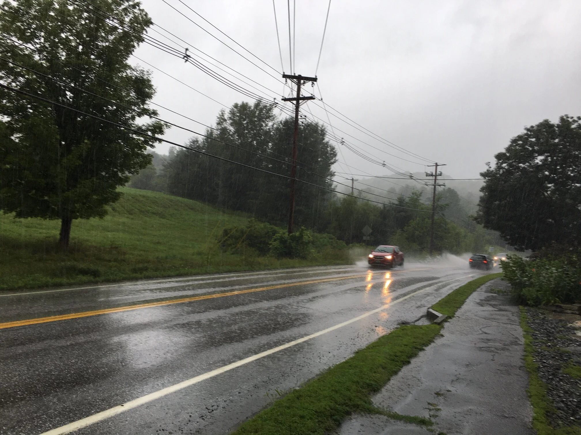
Isaias rips through Northeast
Tropical Storm Isaias is ripping through the Northeast this afternoon with heavy rain and high winds

Tropical Storm Isaias dumps torrential rains on Woodstock, Vermont, on Tuesday. (Gareth Henderson Photo)
Tropical Storm Isaias is ripping through the Northeast this afternoon with heavy rain and high winds, bringing with it the threat of tornadoes and flash floods in the region.
A tornado watch is in effect for most of the Northeast, including southern Vermont, until 9 p.m. Green Mountain Power crews stand at the ready to address resulting outages.
Outages were stacking up mid-afternoon in Massachusetts, Connecticut and Rhode Island, as high winds battered the region.
The high winds are likely to be the greatest cause of damage, experts say, and that was apparent from the impact in New York City, where frequent gusts hit 60-70 mph. Gusts closer to 50 mph are expected in Vermont and New Hampshire, though the Tornado Watch notice says isolated gusts of up to 80 mph are possible in the Northeast.
Check out the National Weather Service for updates on Vermont and the wider region.
— Gareth Henderson

Fay forecast: Week of rain getting started
It looks like we’re about to get all that rain we’ve been missing, after two weeks of moderate drought conditions in Vermont.

Clouds roll in over Lake Nineveh in Mount Holly early Friday evening. (Sherry Boudro Photo)
It looks like we’re about to get all that rain we’ve been missing, after two weeks of moderate drought conditions in Vermont.
At the same time, forecasters warn there may be localized road washouts, so use caution if you need to be out and about.
Moderate to heavy rains from Tropical Storm Fay are expected to intensify Saturday and last into most of next week, according to the National Weather Service. As the ever-deepening dark clouds suggest, the more moderate showers are arriving tonight.
The system will impact most of Vermont, essentially Windsor and Rutland counties and everything to the north, as well as northern New York State. The heaviest downpours appear poised for Saturday, with accumulations of up to 1.5 inches and winds of 10 to 15 mph. Some areas to the north may see up to 2 inches of rain.
Tropical Storm Fay hit New Jersey earlier on Friday, prompting some coastal flooding and road closures as it moved northward. Gusts of up to 25 mph were reported along the coast.
As the system visits the Green Mountains, it obviously brings welcome rains for farmers and gardeners after weeks of drought. But as I mentioned before, caution is urged on the roads as local flooding may occur in some spots depending on rainfall.
Once this storm has passed, hopefully the heat wave will have passed, too. It’s time for Mother Nature to let us out of the oven, at least for a little while.
— Gareth Henderson